December 6, 2009

0 Comments

My Christmas Wish List

wl_wish_list

It’s that time of year again and everyone is asking me what I want. So, let me refer you to my list. It’s not new. I’ve had some semblance of this list on Amazon for over 6 years. Last year I moved it to here.

Last year I asked for cash. I was saving up for a few different options. I finally spent all my Christmas and birthday cash and got a new TV and I love it! One of my bigger projects I’m working to save up for next year is a Mac Mini to plug into that TV and use as a media center (streaming netflix movies and hulu shows). However, I’ll get there sooner or later (even if I need to sell stuff I’ve already got). So, if you’re looking for an idea, go to my wish list. I really want everything on there and there are enough things, it can still be a surprise.

If you have any questions, just ask Sara.

So, for the big list, click here!

November 25, 2009

0 Comments

Happy Thanksgiving

I’ve been a children’s pastor for well over a decade. For years I’ve been responsible for crafty stuff like this that comes home, goes on the refrigerator and then to the trash. Over and over and over again. I’m a little embarrased now that I think about the cheap crafts I’ve punished parents with. Today Titus brought home his first hand turkey. It’s a beautiful multi-colored turkey made from his beautiful and precious hand. I love it. It’s beautiful and I want to frame it. So now I don’t feel so bad about pushing the cheap crafts so hard.

🙂

This thanksgiving I’m especially thankful for my family. By beautiful wife and precious little boy. I’m blessed!

titusturkeyhand

October 25, 2009

0 Comments

I’ve got some places to see!


visited 34 states (68%)
Create your own visited map of The United States

I found this link recently on a friends blog. Sara’s been to a few states I haven’t yet been to, but we’re pretty close to each other. There’s no doubt that I want to visit all 50. You know I’m way into knocking out lists like this one and this one. There’s another challenge we’re working on too that I haven’t posted about yet. Seriously, there are too many great things to do here in Texas!

So, here’s the plan. I’m going to Alaska with my friend Joel when he turns 40. I made that commitment to him 5 or 6 years ago and I’m looking forward to that. It’s still 5 of 6 years away. Sara has wanted to see the leaves change in New England. I told her that it’s something old people do (sorry if that offends any old people reading this blog). So, we know we’re going to do that  sometime, but I’m not sure we’ll hit all the New England state in one trip. Perhaps we’ll do a trip centering around Boston and hit a few surrounding states (I’ve never been to Philadelphia and I’d like to spend some time there). Then we can do the fall colors trip on another vacation.

Of the northern mid-western and western states, it might take 2 or 3 trips. I really don’t have any desire to visit North Dakota or Nebraska except for saying I’ve been there. However I’m a little curious about visiting Green Bay (I have no idea why) and I really would like to see Minnesota (although I have flown through the airport twice). There are many national parts and sites I’d like to see in South Dakota, Montana, Wyoming, and Utah, so those are definite visits. Idaho, I really want to go see it, but the only thing I think about when I think of Idaho is potatoes. I guess I’ll have to see for myself.

So, that’s where I’ve been and that’s my plan for seeing the rest.

September 18, 2009

1 Comment

Ascending Pike’s Peak (part 3)

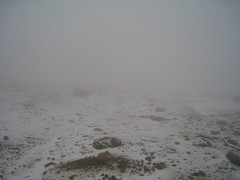
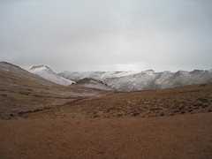
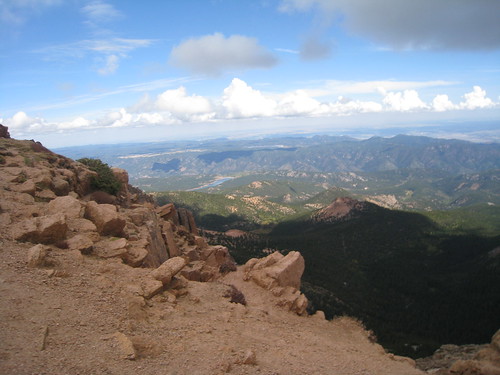
Unfortunately, I do not have many pictures of this final part of our adventure. What was an exciting adventure up to this point morphed into a mission to be accomplished. Although the skies over Colorado Springs were fairly clear, there were dark clouds building on the peak. The summit and at least the final 500 feet of elevation were completely hidden from view.

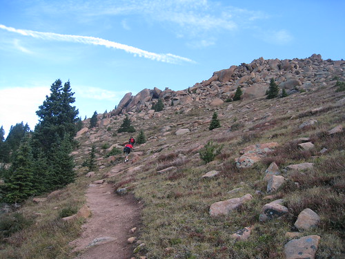
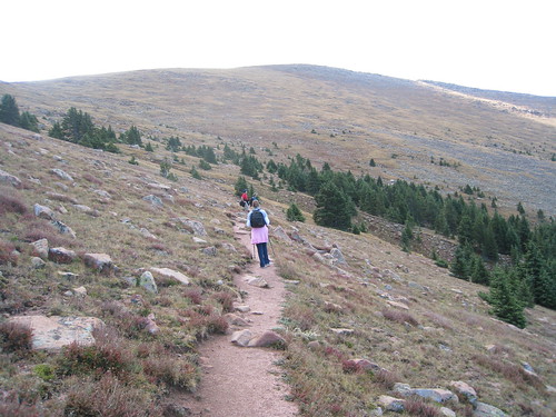
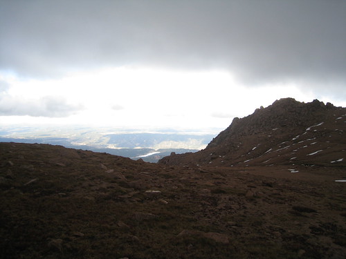
We recognized that our window of opportunity was quickly closing. Afternoon thunderstorms are frequent in the Rockies and a thunderstorm WILL end your quest to summit. Lightning is the leading cause for death in the Colorado Rockies. We continued to push on toward the summit. As we advanced higher into the 13,000 foot rang, our visibility got less and less. Our route kept us anywhere from 50 to 200 feet from the road leading up to the summit. It was getting foggy enough that we could hear the cars, but no really see them as they passed. Since our line of site was getting pretty limited, we had to focus on following the cairns (small stacks of rocks left by previous hikers to show the way) to keep us on the right path. We started to hear the rumble of thunder all around us (probably because we were actually in the middle of the storm cloud by now).

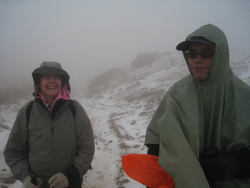
Ever since we crossed the road, we would feel the occasional rain drop. Once in the middle of the cloud, we started to see a little more raindrops mixed in with some sleet/hail. At this time we put on rain jackets/ponchos to keep us dry. It was already cold, so there was no sense in being cold and wet. As soon as we were all covered up and we started moving again, the hail began coming down hard. Pea-sized to marble-sized hail came down for the next 5-10 minutes. When it was light, we continued walking but when it got heavy, we stood motionless waiting for it to subside. The little pellets were somewhat soft but it did sting a little when one hit you in the face. Dad continued to talk to Shayla every 10-15 minutes letting her know that we were okay and that we were still coming.

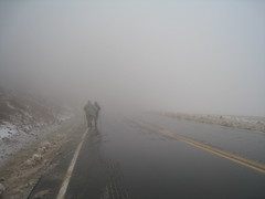
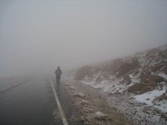
Not too much longer after the ridiculous barrage of ice, visibility shrank to about 30-50 feet. Walt had disappeared in the lead. Sara was in front of me and dad behind me. Eventually Walt came walking back to let us know that the trail was coming along side the road once again. We huddled together for just a minute to decide the future of our hike. Because we were so close to the road, Shayla could drive down and pick us up. After many attempts to get Shayla on the radio (reception had gotten really bad due to the weather) she finally connected and she confirmed that she was coming down.

Sara and Walt in the storm

White Out!

What we didn’t know was that the rangers were in the process of clearing the parking lot on the peak. The weather was getting to dangerous and it was best for everyone to get down off the summit. Shayla told the rangers that she was waiting for four hikers. The ranger seemed concerned. Another ranger confirmed that he had seen us recently where the pavement ended on the road. The first ranger perked up and explained that we were still too far away to make it to the top in a reasonable amount of time and that we needed to get off the mountain. Shayla was beginning to panic. The fog was so bad, she was glad that we were hiking up to be able to drive down. Now that we weren’t going to be able to make it up, she had to drive down the steep mountain road where visibility was only a dozen or so feet in front of you. In addition, she got Dad’s last transmission about her coming to pick us up on the road, but she didn’t really know why. She started to think that maybe one of us was injured. To make things worse, as she got to the road, it had been closed until a scraper truck could come through and clear the ice from the road. Shayla couldn’t get us on the radio again and was concerned that we would be waiting on the road wondering why she wasn’t coming. Later, Shayla would reveal how scared she was. Although is was a pretty crazy situation we found ourselves in (13,300 feet in a storm), Shayla was all alone without complete information and a reliable way to communicate.

In the meantime, us hikers moved to the road. As we began walking up the road, we witnessed a biker on his cruiser wipe out on the wet road. We rushed over to help him pick his bike up again and send him on his way. We continued to walk up the road and no more vehicles were coming down. 10 to 15 minutes passed by and no one had come. There was probably a mile of road between us and the summit, but it should have taken that long for Shayla to get to us. We just continued to walk.

Walt and Dad on the road

Sara on the road

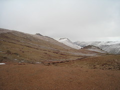
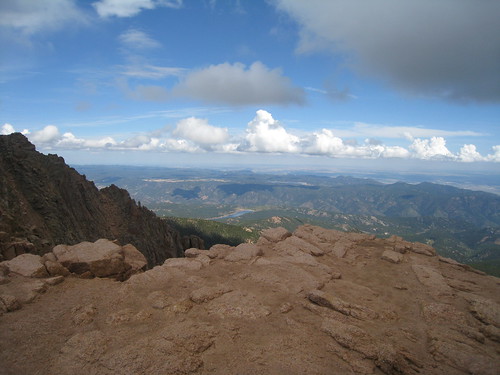
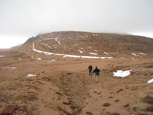
Eventually, we saw the flashing lights of the ranger’s truck with a caravan of cars behind him, including Shayla! We dumped all of our bags and gear into the back and jumped in the Envoy. Only 5-10 minutes into the descent and we were out of the cloud and conditions were clear again. We could see off to the distance many other peaks that were now covered in white, likely the hail that we experience just above.

Snow from our storm

Snow from our storm

While driving down, we replenished our energy on trail mix, beef jerky, sandwiches and fruit. It took about 90 minutes to get back down the mountain and back to the Crags campground to pick up my car at the trail head. After getting my car, it would take an additional 60-75 minutes to get back home. We were beat!

It was a fantastic adventure! We were all disappointed that we didn’t make it to the summit. We were probably a mile away with about 700 more feet of elevation to go. It probably would have taken us another 60 to 90 minutes to summit. Although we were disappointed, we don’t regret our decision to abandon the hike. Conditions were getting bad and our safety and lives were in jeopardy. It wasn’t worth that kind of risk.

So, I think everyone had fun. It wasn’t easy and it was an adventure. I think that all of us would like to do it again. We really just needed a little more time. Next time we just need to get a little earlier start and us flat-landers need to be a little better prepared for the altitude!

September 17, 2009

0 Comments

Ascending Pike’s Peak (part 2)

pikes_peak_summit_to_ne_1

Sara, Titus and I drove in on September 14th. Between late nights and early mornings, we arrived to Colorado Springs pretty tired. As Sara crawled into bed at 10:00 PM, she wasn’t feeling very good at all. I finally got into bed by 11:00 PM, not quite early enough for getting up at 4:00 AM.

At 5:00 AM we were all packed and ready to head out. Although it would be in the 50’s to 60’s at various points on the mountain, the high on the summit was only to be in the low 40’s. We packed snacks, lots of water, rain coats and many layers of clothes for the different temperatures we might encounter. By 6:00 AM, we were eating breakfast at McDonalds in Woodland Park and by 7:20 we were on the trail.

The first mile was a less than strenuous hike through the woods with occasional peeks of rocky outcrops above and the ridge we would eventually have to climb. Our pace was just a little slower than we had planned. At one of our breaks I was was able to get a phone signal and I called Shayla asking her to come to the summit an hour later than planned.

Pikes Peak Trailhead

Sara, Dad and Walt

To Devil's Playground (a long way form here)

Dad on the trail

At about two miles we left the treeline to see the ridge we would have to overcome. It was on this ascent that Sara and I hit a wall. Our spirits were high, but we realized that the altitude was affecting us more than we thought it would. Literally, I was taking fifty steps before stopping to rest and catch my breath. The ascent wasn’t easy, but it was the thin air that was making this part so difficult. Later I would read that overcoming this first ridge was the hardest part of the climb other than the final 500 feet.

A view of the rocks

Treeline

Above the treeline

Sara ahead of me

Once we overtook the ridge, the terrain flattened out substantially. For the first time we could see the peak which was still about 3 miles away. At this point, clouds were building at the peak which meant we needed to pick up the pace. Because the terrain was a little easier we began hiking a little bit faster. After another mile of hiking, we crossed the road that went to the summit, which is the location of Devil’s Playground. Devil’s Playground got it’s name from the way lightning jumps from rock to rock during storms. This is not a place you want to be if weather begins deteriorating.

Sara takes the ridge

Our group enjoys the gentle terrain

Looking back at the gate

Finally at Devil's Playground

Just past Devil’s Playground was the first spectacular view of Colorado Springs on the east side of the mountain. We had been climbing the western side of the mountain all morning and now we had crossed to the other side of the ridge, ready for the final push to the top. Unfortunately, the weather wasn’t looking very good for us. We had originally planned to be on the summit by 11:00 AM before we called Shayla to delay our arrival by an hour. Now it was 12:30 PM and we still had over a mile ago to travel at about 13,100 feet. Fortunately, we had a 2-way radio that we could use to contact Shayla who was waiting at the summit. We let her know that the weather was looking bad, but we were going to push through. The summit was no longer visible and we were heading right into it.

Clouds over the city

Eastern View

Weather degrading as we go higher

Entering the clouds

This is when things got a little scary.

September 16, 2009

4 Comments

Ascending Pike’s Peak (part 1)

pikes-peak-road1

A few months ago Sara and I decided that we wanted to come out to Colorado to see family. Within a few days of talking with family, a family reunion was in the works. It’s been many years since Sara and I have been to Colorado in the summer so we decided that we’d do something we’ve been talking about for years, climbing Pike’s Peak.

I had climbed Pikes Peak when I was 18 years old. It’s one of 54 fourteen thousand foot mountains in Colorado. The famous Barr Trail is 13 miles long with an elevation gain of over 7,000 feet. It’s a long and hard hike. Sara and I began getting ready for our ascent. We joined a gym and worked on preparing for climbing this mountain.

Unfortunately, life has a way of getting busy. Sara started getting worried about being ready for the 13 mile ascent. I wasn’t willing to do this hike without her, so we decided to take a secondary and less traveled route up the same mountain. It’s only a 6 mile hike with a 4,000 foot elevation change. Sara’s dad and brother-in-law, who decided to hike with us, were fine with our change.

So, due to a small window of favorable weather, we decided to climb the mountain on September 15th. Afternoon storms are frequent in the Rocky Mountains so it was important to reach the summit as close to noon as possible. This meant an early start for us. Our plan was to begin hiking at 7:00 AM. A moderate pace should have gotten us to the top by 11:00 AM.

Since we were not doing the more difficult Barr Trail, I had decided to make the round trip. While Shayla, Sara’s sister, intended to pick us up on the summit (Pike’s Peak is only one of two 14ers that you can drive to the top), Sara’s Dad and I were going to hike back to the car and meet the rest of the family back at the house.

This was the plan. As you know, things don’t always go as planned.

Below are pictures of this hike along with directions from a website dedicated to hiking Colorado 14ers.

pike1pike2pike3pike4pikelast